


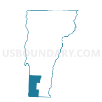
Sandgate Voting District, Bennington County, Vermont
About
Outline

Summary
| Unique Area Identifier | 680715 |
| Name | Sandgate Voting District |
| County | Bennington County |
| State | Vermont |
| Area (square miles) | 42.20 |
| Land Area (square miles) | 42.14 |
| Water Area (square miles) | 0.07 |
| % of Land Area | 99.84 |
| % of Water Area | 0.16 |
| Latitude of the Internal Point | 43.18479030 |
| Longtitude of the Internal Point | -73.18026670 |
Maps


Graphs
Select a template below for downloading or customizing gragh for Sandgate Voting District, Bennington County, Vermont


Neighbors
Neighoring Voting District (by Name) Neighboring Voting District on the Map
- Voting District 150002, Washington County, NY
- Voting District 150003, Washington County, NY
- Arlington Voting District, Bennington County, VT
- Dorset Voting District, Bennington County, VT
- Manchester Voting District, Bennington County, VT
- Rupert District 1, Bennington County, VT
- Rupert District 2, Bennington County, VT
- Sunderland Voting District, Bennington County, VT
Top 10 Neighboring County Subdivision (by Population) Neighboring County Subdivision on the Map
- Manchester town, Bennington County, VT (4,391)
- Salem town, Washington County, NY (2,715)
- Arlington town, Bennington County, VT (2,317)
- Dorset town, Bennington County, VT (2,031)
- Sunderland town, Bennington County, VT (956)
- Rupert town, Bennington County, VT (714)
- Sandgate town, Bennington County, VT (405)
Top 10 Neighboring Elementary School District (by Population) Neighboring Elementary School District on the Map
- Manchester School District, VT (4,391)
- Mettawee Community Union School District 47, VT (2,191)
- Dorset School District, VT (2,031)
- Sunderland School District, VT (956)
Top 10 Neighboring Secondary School District (by Population) Neighboring Secondary School District on the Map
Top 10 Neighboring Unified School District (by Population) Neighboring Unified School District on the Map
- Cambridge Central School District, NY (6,547)
- Salem Central School District, NY (4,034)
- Arlington School District, VT (2,317)
- Sandgate School District, VT (405)
Top 10 Neighboring State Legislative District Lower Chamber (by Population) Neighboring State Legislative District Lower Chamber on the Map
- Assembly District 112, NY (139,495)
- Bennington-4 State House District, VT (4,391)
- Bennington-Rutland-1 State House District, VT (4,130)
- Rutland-8 State House District, VT (3,988)
- Bennington-5 State House District, VT (3,776)
Top 10 Neighboring State Legislative District Upper Chamber (by Population) Neighboring State Legislative District Upper Chamber on the Map
Top 10 Neighboring 111th Congressional District (by Population) Neighboring 111th Congressional District on the Map
Top 10 Neighboring Census Tract (by Population) Neighboring Census Tract on the Map
- Census Tract 9704, Bennington County, VT (4,391)
- Census Tract 9706, Bennington County, VT (3,084)
- Census Tract 900, Washington County, NY (2,715)
- Census Tract 9707, Bennington County, VT (2,317)
- Census Tract 9702, Bennington County, VT (2,031)
- Census Tract 9703, Bennington County, VT (1,119)
Top 10 Neighboring 5-Digit ZIP Code Tabulation Area (by Population) Neighboring 5-Digit ZIP Code Tabulation Area on the Map
- 05255, VT (4,121)
- 12865, NY (3,663)
- 05250, VT (3,408)
- 05251, VT (1,350)
- 12873, NY (736)
- 05776, VT (714)